The University of Bremen is participating in a major research project to develop techniques for navigating in deep ice. The aim is to prepare a space mission to search for extraterrestrial life on the Saturn moon called Enceladus. Under its several-kilometer-thick ice cover, Enceladus houses a global watery ocean. An autonomously navigating ice-melting probe is to locate, drill, collect and analyze fluid samples taken from under the ice surface. The project aim is to prepare a space mission to search for extraterrestrial life on the Saturn moon Enceladus. Under its several-kilometer-thick ice cover is a global ocean of water. An autonomously navigating ice-melting probe is to locate water-filled cracks under the ice surface, drill down to them, and collect fluid samples for analysis.
Tests in the Alps
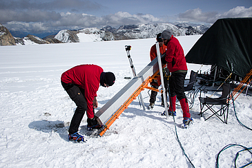
The Enceladus Explorer Initiative (EnEx) was thought up by DLR Space Management. Recently, 20 scientists gathered to conduct an intensive three-week glacier test. The team members were drawn from the RWTH Aachen University of Technology (RWTH), which coordinated the glacier test, the Aachen University of Applied Sciences, the Braunschweig University of Technology, as well as researchers from the Department of Mathematics and Computer Science at the University of Bremen and the Aachener Gesellschaft für Systementwicklung und Instrumentierung (GSI) GmbH. Already last year, a land survey carried out by the RWTH showed that the environment of the high alpine refuge Refugio Gianni Casati on the Langenferner Glacier in the Ortler Alps would serve as an ideal place for testing the navigation systems.
Geolocation 20 meters under the ice
The field test on the glacier at an altitude of more than 3,000 meters was successful: During the expedition, the researchers tested a new network comprising several autonomous ice-melting probes. The aim was to determine the position of a navigable probe using ultrasound. The researchers carried out surveying measurements at depths of more than 20 meters under the ice. In addition, the probe network should be capable of identifying obstacles to drilling in the ice.
Responsible for autonomous navigation
The data collected by all the individual systems were forwarded via the surface station directly to the computers of the project “EnEx-CAUSE” in the Department of Mathematics / Computer Science at the University of Bremen. Here, two working groups are involved in the project. The “Cognitive Neuroinformatics” led by Professor Kerstin Schill develops the algorithms used for geolocation as well as the position of all the melting probes and the mapping of obstacles in the ice. In addition to this, procedures for autonomous decision-making and exploration are being researched and tested. The group “Optimization and Optimal Control” led by Professor Christof Büskens is responsible for planning the path the navigable melting probe should take. This is then controlled by algorithms and runs independently.

